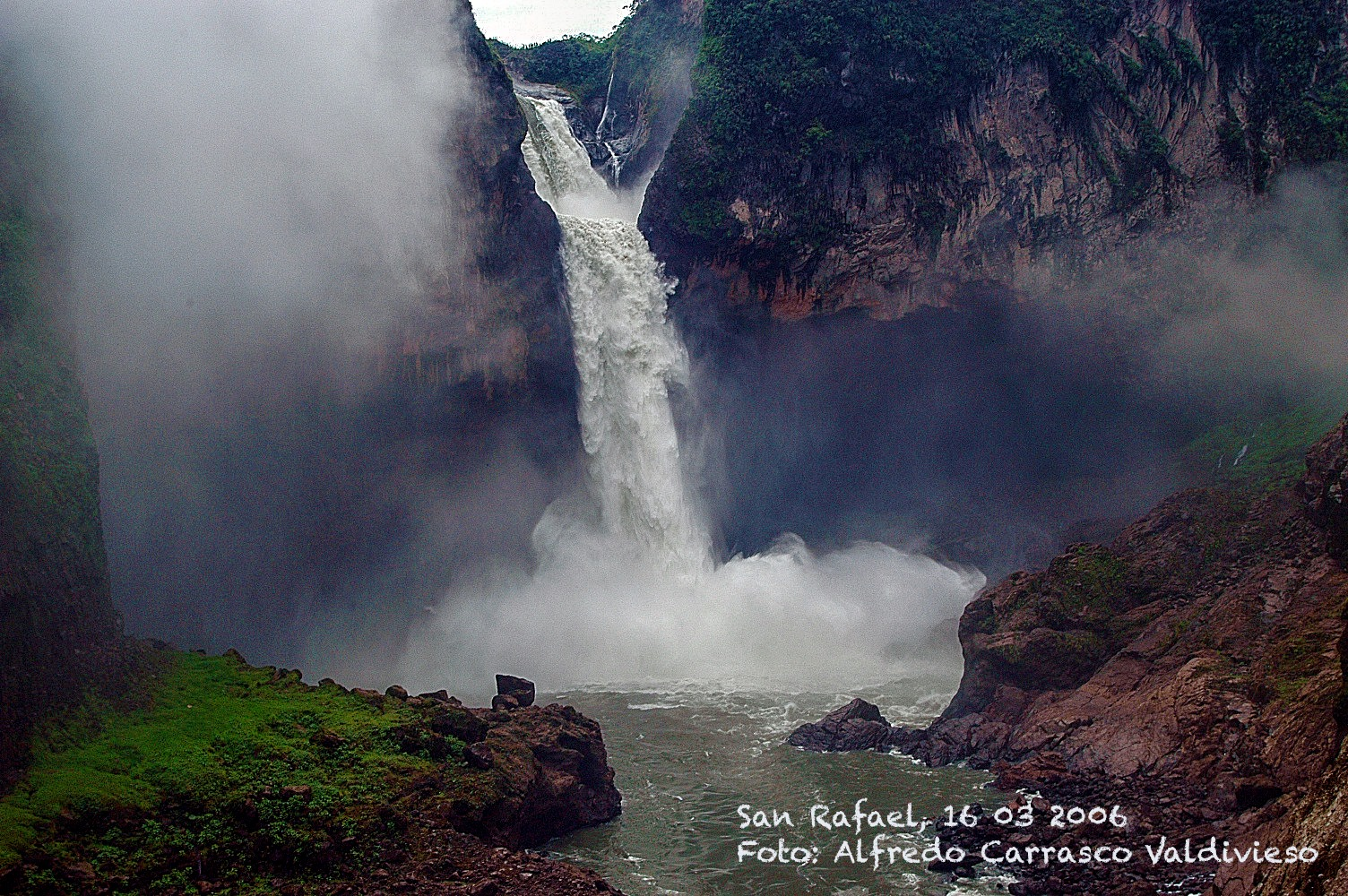
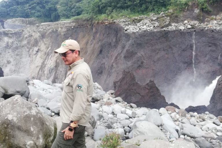
On February 2, something strange happened in Cayambe Coca Park in the Ecuadorian Amazon. The emblematic San Rafael waterfall, located on the Coca River between the provinces of Napo and Sucumbíos, disappeared from its home of thousands of years.
The 150-metre-high waterfall – the highest in the country and a big tourist draw – stopped being part of the landscape. A huge hole appeared in the riverbed, just before the original fall. Now the water falls a few meters behind it, divided into three sections and with a less steep slope. The river flows under an arch that survived the collapse of the land, but from the place where it used to be photographed, it’s as if it never existed.
Sucumbíos province’s Emergency Operations Committee (COE) has restricted access to San Rafael and the Ministry of Environment (MAE) announced that it is carrying out studies to determine what happened. Ecuadorian scientists are surprised by an event that cannot be remembered in Latin America’s recent history – be it natural or caused by human activity.
Waterfall before: Photo by Ministry of Tourism Ecuador. Waterfall after: Ministry of Environment Ecuador.
San Rafael’s volcanic, seismic origins
Alfredo Carrasco, a geologist and former secretary of Natural Capital at the ministry, says the event is fascinating. The San Rafael waterfall did not actually disappear. Rather, the river changed its course and the water now falls upstream. It is located in an area of seismic and volcanic activity near the Reventador volcano, one of the most active in the country having last erupted a decade ago. Its lava and strong earthquakes that eroded the mountains thousands of years ago formed San Rafael.
“There are many quite intense earthquakes here. In March 1987, a very strong one appeared that caused tremendous damage to the trans-Ecuadorian oil pipeline that passes right through it,” Carrasco recalls. “That year I had the opportunity to evaluate the impact of the earthquake in that area. There were floods of up to 20 meters above the level of the valley where the river passes.”
Carrasco continues to analyse the formation of the San Rafael waterfall and ensures that at the same time as volcanic activity caused the natural damming of the river, a natural process of water erosion began towards the base of the dam. “It is very typical that the energy of the water falling erodes the base. For me, the phenomenon [the collapse of the waterfall] is eminently of natural origin,” he says.
However, what now worries Carrasco is that the new place where the river falls at three separate points is not an area with consolidated sediment. These new falls cause a process of ‘regressive erosion’, triggering a river upstream, which will change the morphology of the valley.
Carrasco says that in 30 to 50 years’ time these new waterfalls could be between three and five kilometres higher.
“It’s a very interesting phenomenon that will have to be monitored,” he says.
Hungry waters: A possible explanation
Emilio Cobo, coordinator of the South America Water Program at the International Union for the Conservation of Nature (IUCN), is concerned that the environment ministry cannot conclusively report on what happened at San Rafael.
“It must be very difficult to measure what happened and if there is a clear answer because I’m not sure that the ministry has the ability to investigate it. We don’t know if there were previous studies or monitoring of the area.”
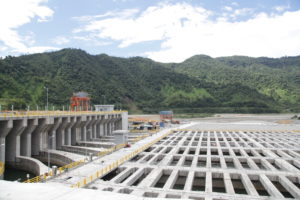
For Cobo, it is very important to know if erosion in the area was monitored before and after the construction of the Coca Codo Sinclair hydroelectric plant, one of the largest in the country. Coca Codo Sinclair’s diversion reservoir (the plant’s intake is ‘run-of-the-river’, not from a dam) is some 20 kilometres upstream from the San Rafael waterfall.
A waterfall that has been there for thousands of years does not collapse, coincidentally, a few years after opening a hydroelectric project
Coca Codo Sinclair is one of eight hydroelectric plants built by Chinese companies or financed by Chinese banks in Ecuador, part of plan to transform its electricity matrix that has so far depended mostly on coal-fired thermoelectric plants.
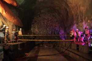
The work, constructed by Sinohydro and financed by China EximBank, has had problems with cost overruns, worker strikes, and accidents such as the 2014 collapse of a pressure well that claimed the lives of 14 workers. It was inaugurated in 2016, four years later than scheduled.
Mongabay contacted the ministry to ask about the existence of official technical information, previous monitoring and any link between the diversion reservoir and the erosion of the waterfall. It responded that the governor of Sucumbíos, is the official spokesperson. Governor Tony Rojas had not responded to requests for comment by the time of publication.
Emilio Cobo hypothesises that the hydroelectric plant is indirectly related to the collapse of San Rafael.
The Coca Codo Sinclair plant is not located on the river, but the diversion reservoir itself has a system of sand traps that remove sediment so as not to affect its operation. “When a river loses sediments, water increases its erosive capacity, an effect called ‘hungry waters’,” says Cobo. “All rivers carry eroded sediments from the soils and rocks on which they pass. All dams and reservoirs trap part of this sediment, especially heavy materials, and thus deprive the downstream river of its normal sediment load.” Large reservoirs and dams will typically trap more than 90%, and sometimes 100%, of the incoming sediment, Cobo says.
Did you know…?
Ecuador has more rivers per square kilometre than any country in the world
The clear water under a dam is said to be ‘hungry’ and will seek to recover its sediment load by eroding the river bed and banks, Patrick McCully writes in his book Silenced Rivers: The Ecology and Politics of Large Dams.
While many Ecuadorian researchers find it hard to believe that the Coca Codo Sinclair plant influenced what happened with San Rafael, Emilio Cobo is convinced it was no coincidence.
“A waterfall that has been there for thousands of years does not collapse, coincidentally, a few years after opening a hydroelectric project. These are processes that are in scientific papers and there is sufficient evidence that a dam can cause effects of this type on a river,” he says.
The collapse of San Rafael is such an important event for scientists that IUCN is set to hold an academic debate to find stronger scientific ground to determine what happened.
Jorge Celi, director of the National Water Reference Laboratory of the Ikiam Amazon Regional University, also believes that there could be relationships between the hydroelectric plant and the waterfall’s collapse.
“What happened is not common, it should happen once every 1000 years, but I think it’s a process that is accelerated a bit more by human activities in the basin,” he says.
There’s no consensus that Coca Codo Sinclair is responsible for what happened and the company has not responded to requests for information.
Fears that the river would run out of water because of the plant’s construction has long been a concern. According to Cobo, Coca Codo Sinclair’s environmental study details the erosive processes and sediment dynamics that would be affected by the work, but can’t say what implications this will have over decades. “The designs of works and the way they were built- in the sixties and seventies did not consider climate change factors, for example” he says.
What will happen?
Although geologist Alfredo Carrasco believes the collapse of the San Rafael waterfall to be a natural phenomenon, he agrees with Cobo and Celi that the current risk is that the river bed, upstream, will continue to erode and cause new landslides.
“In the future, it could potentially affect the site where the waters of the hydroelectric project are captured. But we would have to do a risk analysis, I don’t want to speculate too much,” says Carrasco.
For Jorge Celi, it is difficult for corrective measures to be taken unless the dam releases sediments. “If the sink deepens, the edges are more susceptible and new landslides could happen,” he says.
Celi believes that the collapse of the San Rafael waterfall would not mean a big impact on nature, since this has served as a geographical barrier for many species for centuries.
“If the barrier [waterfall] had completely disappeared, connectivity would have increased and some migratory fish could climb upstream. The effect of what happened is that many sediments were suddenly released, but after a while the rivers recover from those landslides,” he says.
Cobo believes that there will be “very serious” impacts on infrastructure in the Coca River channel between the waterfall and the collection dam that could compromise the future of the hydropower plant. If the river depth increases by three or four meters, the structures of bridges will be compromised. Houses and other works could also be affected. He is sure there will be costs that the State will then have to deal with.
Cobo is concerned about the impacts the erosive processes may have on freshwater species such as fish and macroinvertebrates, the groups that have lost most species in the last 30 years, according to the IUCN Red List of endangered species. Many more could follow.
Ecuador has more rivers per square kilometre than any country in the world, but Cobo says there is said a regional concern about what happened at San Rafael and the state of Latin America’s rivers.
Many populations depend on fish protein. The absence of fish means more hunting for monkeys and other species in the jungle. “In the scientific world, many do not see rivers as ecosystems, when in reality it is a reduced surface that ends up absorbing many of the environmental impacts,” Cobo says.
The discussion about what happened with the San Rafael waterfall on February 2 promises will occupy scientists for a long time. There are still more doubts than certainties and many contradicting views. An in-depth analysis is a must. The researchers hope that this work will help Ecuador to become aware of its strengths, weaknesses, successes and errors in environmental matters.
Alfredo Carrasco recalls the strong earthquake that in 1987 altered the level of the river in this area, he took photographs and analysed them. “After what happened on February 2, I will be taking pictures very soon,” he says.
This story originally appeared on Mongabay Latam.