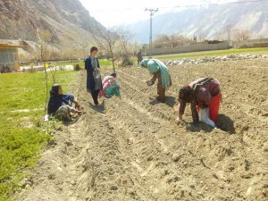
![<p>Agriculture is the major source of livelihood of the Mising people who live on riverbanks in Assam [image by: Varsha Torgalkar]</p>](https://dialogue.earth/content/uploads/2020/03/Agriculture-is-major-source-of-livelihood-of-Mising-tribe-who-stays-along-the-river-banks.-768x576.jpg)
“Floods come every year,” said Rajeshwari Doley, a middle-aged woman from Majuli, an island formed by the Brahmaputra river in the Indian state of Assam. She has no faith that the government will, or can, do much to deal with the recurrent crisis. At most, she hopes that the government will provide additional seeds for agriculture after the floods.
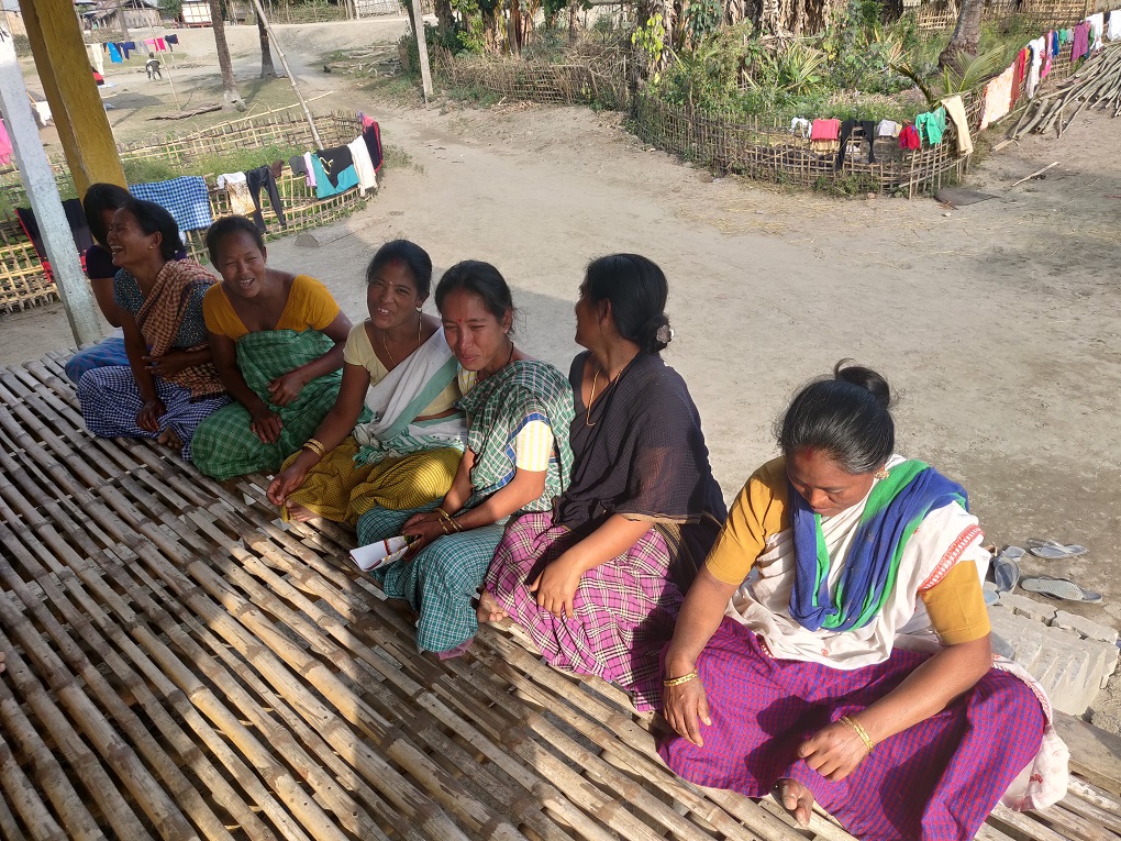
She spoke to thethirdpole.net while sitting with her fellow village women in her bamboo house. Typical in construction to other houses in the area, it rests on stilts raising it four feet (1.3 metres) above the ground.
Rajeshwari and the other 500 or so members of the Mising or Miri community living in Kulamua village were unaware that the government is obliged to provide shelter, food and drinking water during and after floods. These have hit the village situated on the bank of the Subansiri river every year for decades.
![Rajeshwary Doley (left) and Tengo Pegu (second from right) [image by: Varsha Torgalkar]](https://dialogue.earth/content/uploads/2020/03/Rajeshwary_Doley_at_left_and_Tengo_Pegu_second_from_right_sitting_at_balcony_of_stilt_houses_.jpg)
Majuli, the world’s biggest river island, is surrounded by Brahmaputra river in the south and Kherkutia Zuti and Subansiri rivers in the north. Spread over 880 square kilometres about 100 years ago, the island has shrunk to 352 square kilometres due to land erosion.
See: Saving Majuli, is it possible?
Assam is the most vulnerable state among 12 Himalayan states in India to climate change, as per Climate Vulnerability Assessment for the Indian Himalayan Region Using Common Framework, the study carried out by Indian Institute of Technology Guwahati and IIT Mandi under the Ministry of Science and Technology. And Majuli is one of the areas in Assam most vulnerable to climate change impacts.
A majority of the people living on river islands or riverbanks lack of access to information and infrastructure, making them more vulnerable.
The most vulnerable
Mising (also called Miri) are among the marginalised indigenous communities of India classified as Scheduled Tribes (STs) in the Indian Constitution. The Mising are the only community in North East India that still live along the banks of the Brahmaputra and Subansiri rivers, according to the Mising Autonomous Council (MAC).
Their population is approximately 700,000 in Assam and 30,000 in Arunachal Pradesh. They depend on agriculture, fishing, piggery and weaving for livelihood. As per the 2001 census, literacy rates among Miris was 60%, with 71% of men and 48% of women literate, making them second from last in literacy rate among STs.
“Floods, land erosion and siltation of non-fertile sand coming from the Himalayas are major issues that communities staying on river banks face.”Partha Jyoti Das
In Majuli, 40% of the 165,000 residents are from the Mising community, according to the 2011 census. Paramananda Chayengia, chairman of MAC said, “90% of the population depends on agriculture, fishing and piggery for their livelihood and the majority of them are poor. Though the literacy rate is 60% they are not employed.”
Partha Jyoti Das works at Aaranyak, an environmental organisation based in Guwahati, the largest city in Assam. He has been studying land erosion for years. “Floods, land erosion and siltation of non-fertile sand coming from the Himalayas are major issues that communities staying on river banks face,” he said. “Communities find it difficult to cope with floods in the recent years as the timing, frequency and speed [of the floods] have become erratic. Earlier communities would be aware that floods would come from April to June and they would prepare themselves.”
Rajeshwari said, “We know that floods generally hit the village in April or May and we fix or rebuild the house before [those months]. Stock of grocery, firewood, food for cattle, pigs, are kept ready. Pigs, chicken and cows are kept in stilt houses separately built for them.”
The residents do not know of any system by the state government to provide flood alerts. During floods, they commute with boats. All families own either wooden boats or rafts made of banana trunks.
Tengo Pegu, another resident, said that if floods were severe and water levels rose by more than 5-6 feet (up to 2 metres), they would go to an elevated platform in the central part of Majuli, “Firewood gets wet during floods and rain and we struggle to cook. Our chicken, pigs die. Seeds also get damaged due to moist weather and we have to buy after floods for Rabi cultivation.”
Although the people have traditionally found shelter even in the worst of floods, this is now changing. Pegu said, “Generally floods hit once or twice in April and May and remain for a week or two. But in 2018, floods came thrice and we had to run towards the central part [of the island] to protect ourselves.”
Aniket Chavan, who teaches at a community school, said that the communities in the area were unaware of the need to drink purified water. There are hand-pumps at courtyards of every house. “There are no plants to purify water. Water gets dirty after floods but they have to drink it anyway due to absence of purification plants.”

Clothes hand on cement tetra-pods that are being built to stop erosion at the banks of Subansiri river in Kulamua village of Majuli. This is the one visible government intervention to provide some form of protection against floods and erosion. Nageshwar Pegu, a farmer who owns three acres of the land and grows rice, pulses and vegetables, said, “5-6 tetra-pods that were built a few years ago cannot stop land erosion. They need to build a boundary of such tetra-pods.”
After the floods, the local communities cannot farm till the water recedes. “[Without income we cannot afford to buy vegetables,” Tengo Pegu said.
Even if they had money, the villagers find it difficult to commute to Garmur or Jorhat towns to buy grocery or for healthcare. Floods damage roads as well.
Flooded, cut off, and increasingly vulnerable, the Mising are “missing” from the government’s care.
thethirdpole.net has sent queries to district administration asking what measures are taken to alert villagers about floods, how shelter is arranged during floods and food and clean water is provided. This report will be updated if, and when, a reply is received.
![The Mahakali river at the India-Nepal border, downstream of the Sharada barrage [Image by: Joydeep Gupta]](https://dialogue.earth/content/uploads/2020/03/Mahakali_Sharada_barrage_JG-300x225.jpg)