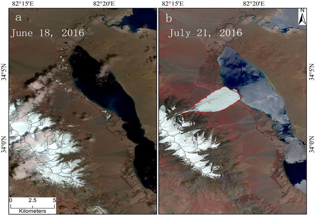
In a remote region of central Tibet in July 2016, part of the Aru Glacier collapsed. Around 77.6 million cubic metres of ice, spread over 9.5 square kilometres and weighing seven million tonnes, detached from the glacier and crashed into a lake below. The waters of the lake were pushed 250 metres away from the shore as the falling ice created a wave nine metres tall. A mark from the wave is still visible.
Experts from the Institute of Tibetan Plateau Research (ITPR), which is part of the Chinese Academy of Sciences, had just started to examine this extraordinary collapse when a second occurred in September 2016. This time, 72 .8 million cubic metres of ice crashed down the mountain slope — almost 6.7 million tonnes of ice.
The glacier is located in areas without any permanent human habitation; there are only nomadic herders and, sometimes, scientists in their monitoring stations. As a result, these extraordinary events have gone largely unnoticed, though they have been noted with great concern by glaciologists around the world. Experts from the ITPR who are studying the events on the ground and with satellite imagery, say that the collapses may have been caused by climate change. But glaciology experts from outside of China are more definitive – the collapses were definitely caused by climate change, they say.
“If these [collapses] were due to climate change, then they may not be the last disasters, but rather a sign of the start of a new type of glacier hazard. This is what worries glaciologists the most,” said Tian Lide of ITPR to a group of Chinese and Indian journalists at a recent Indus Basin media forum, organised by the International Water Management Institute and thethirdpole.net.
 Images of Aru Glacier in central Tibet before and after the collapse on July 17 2016. (Image courtesy: Tian Lide, ITPR)
If the ice that crashed down from the Aru Glacier collapse had fallen into the stream at the bottom of the valley, it would have dammed the stream, creating a potential flash flood hazard, Tian warned. “Glacier monitoring work is necessary and an early warning system is urgent to diminish the damage caused by glacier hazards,” he added.
The ITPR has a network of five permanent monitoring stations – in Muztagata, Ngari and Namco glaciers, in the Everest region, and in south-eastern Tibet. What scientists are finding everywhere is that glaciers are melting faster. But the melting rate is not uniform – the further east one goes, the faster glaciers melt. Those in the Himalayas are melting fastest, the ones in Pamir the slowest.
Faster glacial melt is one of the most worrying consequences of climate change because it impacts water availability in the rivers downstream, including rivers such as the Indus, the Ganga and the Brahmaputra on which more than one billion people depend for their daily needs and livelihoods.
That is also why glacier retreat data is often contested. Scientists now agree that the most authentic way to measure glacier retreat is by “mass balance”, monitoring the actual mass of ice in a glacier over the years. It is also the most difficult way to monitor a glacier because it cannot be done through satellite imagery alone, scientists must travel to various points on the glacier again and again to get the depth of the ice so that they can calculate the mass.
 Accumulated glacier mass balance for 11 glaciers from 2006 to 2010 (Source: ITPR)
Scientists from the ITPR have been calculating the mass balance of 11 glaciers in Tibet since 2006 and have found that 10 are in retreat. The data for 2006 to 2010 has appeared in peer-reviewed academic journals.
The results of the faster melt are there for all to see: expanding lakes, inundated grasslands, floods, and a desert left behind when the water flows away. The ITPR scientists have found that throughout Tibet the number and sizes of lakes have increased dramatically since 1970. Policymakers are already worried about the consequences of glacier retreat. The collapse of large parts of glaciers takes that threat to a new level.
This article originally appeared on The Third Pole and is republished here with permission.


![A woman pumps up water from a tubewell in West Bengal despite the red cross that signifies that there is an unacceptable level of arsenic in the water [image by Dilip Banerjee]](https://dialogue.earth/content/uploads/2017/09/Woman-at-tubewell-West-Bengal-Image-by-Dilip-Banerjee-1-300x206.jpg)
