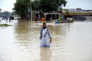
August was a particularly difficult month for the Indian Himalayan states of Uttarakhand, Himachal Pradesh and Jammu and Kashmir. Multiple floods during the peak of the Hindu pilgrimage season caused widespread destruction and loss of life. Downstream, Punjab suffered some of its worst floods in recent years, as swollen rivers submerged villages and farmland.
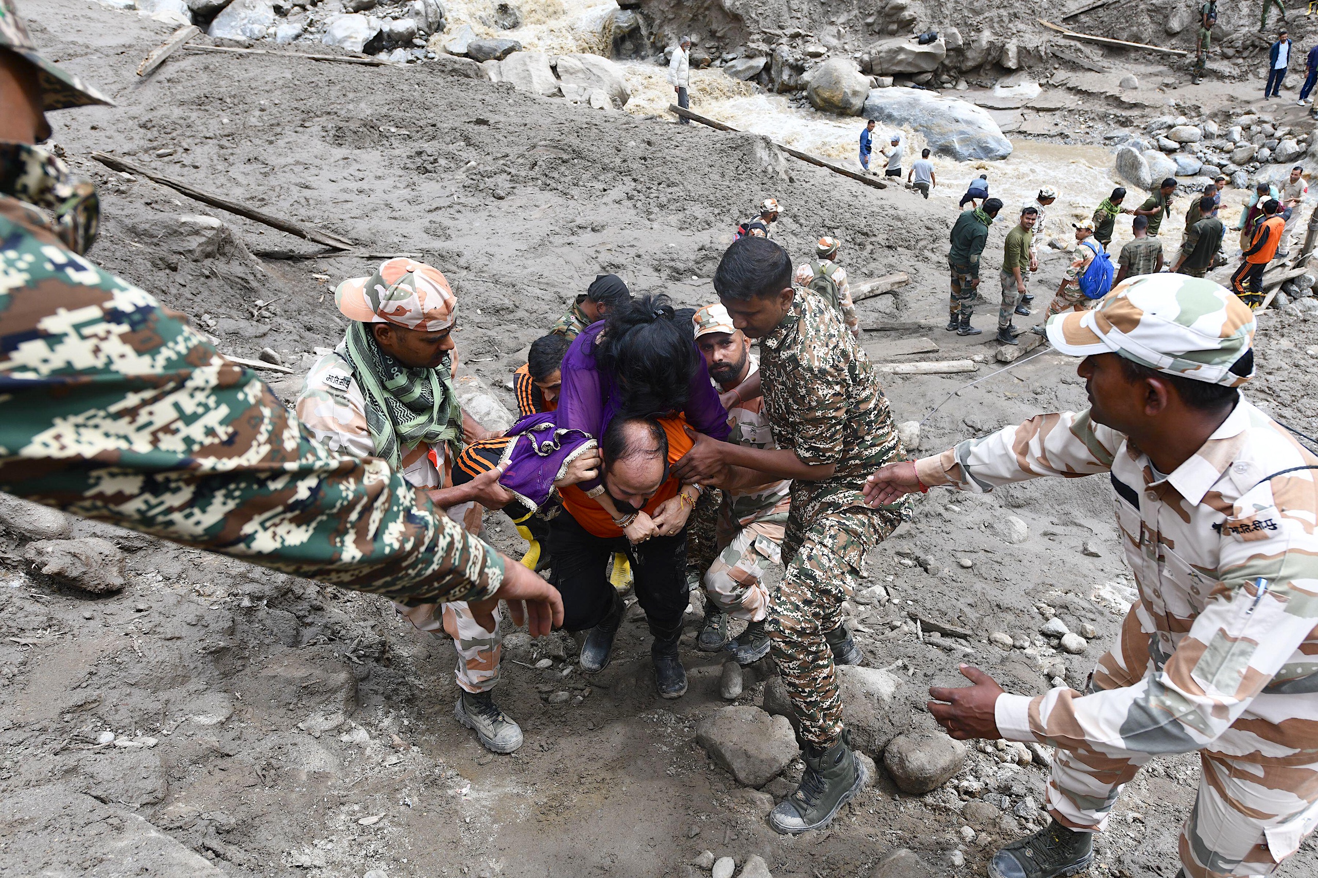
On 5 August, a flash flood triggered by intense rainfall caused debris-laden flows into Dharali and Harsil villages in Uttarakhand, sweeping away homes, bridges and roads. Some initial media reports and government authorities attributed the flood to a “cloudburst”. The India Meteorological Department (IMD) defines this phenomenon as at least 100 mm of rain falling within an hour over an area of 20-30 sq km.
Nine days later, another flash flood in Jammu and Kashmir’s Kishtwar district, also attributed to a cloudburst, killed at least 65 people and left 32 missing.
Yet in both the Uttarakhand villages and Kishtwar not enough rain fell before the floods to qualify as a cloudburst. IMD officials have also told the press that the data available on the floods in Uttarakhand “does not reflect the occurrence of a cloudburst”.
Since 24 August, India’s Jammu region has been experiencing record levels of rainfall resulting in landslides. In Doda district, media reports, district-level administration, as well as the region’s chief minister have cited a cloudburst as causing the landslides. In Himachal Pradesh, dozens of hilly roads were blocked or damaged from flood-induced landslides, leaving thousands of Hindu pilgrims stranded.
Experts Dialogue Earth spoke to note that the actual drivers of these terrible events remain uncertain. So why is the cloudburst label so commonly applied?
Beyond cloudbursts
While cloudbursts can cause devastating floods and damage, “it is not necessarily the main cause” for every occurrence, says Madhavan Nair Rajeevan, the former secretary of India’s Ministry of Earth Sciences. “Even heavy rains of less than 100 mm in one hour occurring in 2-3 hours can cause these flash floods.”
This is especially true with rain in the mountains. “The valleys act like a funnel, collecting the rainwater at the valley bottom that flows downstream rapidly and destroys whatever comes in its way,” explains Mohd Farooq Azam, senior intervention manager for the cryosphere at the International Centre for Integrated Mountain Development (ICIMOD).
Only field observations and monitoring equipment can confirm the event as being a cloudburst, he notes. Currently, the IMD monitors rainfall mainly through automatic weather stations (AWS), rain gauges and satellite data. It has also progressively installed 10 Doppler Weather Radars (DWR), which use high-power microwave radiation to detect precipitation, over the north-western Himalayas beginning in 2021. It has plans to expand the national network to 126 by 2026.
Until then, there remains various challenges in identifying cloudbursts in the Himalayan region, says Himanshu Thakkar, coordinator of the South Asia Network on Dams, Rivers and People. One is that the IMD has insufficient monitoring stations in the Himalayan region. For example, Dharali’s closest AWS station is 7 km away.
Another is that cloudburst-measuring equipment such as rain gauges, which are generally more common as they are cheaper than AWS, have limited ranges. Yet “IMD’s density of rain gauge[s] is very low,” says Thakkar. In the Himalayas, rainfall can differ sharply over short distances due to the steep topography, and peaks and ridges can block DWR signal. These factors make it challenging to accurately determine how much rainfall an area has received.
Rajeevan notes that while several DWRs have been installed in the Himalayas, many are still not functional due to lack of manpower, supporting facilities and infrastructure. Thakkar adds that satellite monitoring is often hampered by cloud cover during the monsoon.
Rajeevan carried out his own analysis of the rainfall patterns preceding the recent August floods. He believes they were triggered by a “western disturbance” passing over the region, supported by moisture-laden monsoon winds in the lower levels. “A deadly combination for heavy precipitation,” he says.
A western disturbance is a storm originating in the Mediterranean region and occurring outside the tropics. The low-pressure disturbance carries moisture from the Mediterranean and Caspian seas eastward, via the subtropical westerly jet stream. This can bring rain and snow to Pakistan and northern India.
Typically, there are more of these storms during the winter months. But studies have shown that over the last two decades, western disturbances were twice as common in June as they were in that month over the previous half century. This means they are likely to remain in the area as the monsoon develops.
Experts say this kind of coupling of two weather systems will increase with global warming, meaning that intense rainfall events also become more frequent.
Disasters oversimplified
The Himalayan system is complex. Disasters in the region may be the result of an interplay of several factors, such as receding glaciers, thawing permafrost, landslides, snow avalanches, local topography and extreme weather events, Azam says.
In recent years, for example, events such as the South Lhonak glacial lake outburst flood in 2023 and the Til village flash flood in May 2025 were primarily caused by permafrost-linked landslides, Azam notes. With global warming, permafrost is now thawing, destabilising slopes and causing failures.
Despite these varied causes, India has a history of initially misattributing the causes of floods. When the Chamoli disaster in Uttarakhand struck in February 2021, media reports and authorities variously called it a cloudburst and a glacial lake outburst flood. But in a report published the following month ICIMOD showed there was no significant lake upstream. The real trigger had been a massive rock-ice avalanche, starting at 5,500 metres and cascading into two rivers, ICIMOD explained.
Even the 2013 Kedarnath flooding, one of India’s worst disasters, with over 6,000 deaths, was initially labelled a cloudburst, a descriptor denied by the IMD days later. Subsequent studies found the event to be a combination of extreme, sustained rainfall linked to snowmelt and overflow from an upstream lake. The lack of automatic rain gauge or hourly measurements meant the occurrence of cloudburst could not be determined. The flood’s impact was exacerbated by debris from landslides and collapsed riverbanks rushing into Kedarnath.
Experts warn that such oversimplifications conceal the role of fragile slopes, deforestation, road-cutting and unregulated construction.
Unplanned and rampant infrastructure development in the region plays a significant role in these disasters, Thakkar says. When rains flow down from the hills, they bring with them mud and stones, mixed in with construction waste from road-building projects. Such waste is often dumped in rivers and along slopes in the Himalayas. This combination can cause devastating flash floods in areas surrounding the rivers, he notes.
As such, “describing the cause of these disasters as cloudbursts or landslides isn’t good enough”, he says. “What’s needed is an independent, multidisciplinary assessment of Himalayan disasters to understand what exactly happened and to [show] accountability.” The assessment would highlight any “geological, meteorological, systemic, social or environmental factors as well as the role of infrastructure development and different agencies.”
The way ahead for the fragile Himalayas
Thakkar says that, “considering the vulnerability of the Himalayan region and its subsequent disaster-proneness”, the IMD and state governments need to build up monitoring equipment infrastructure to not only measure the rainfall post-disaster but also use it to forecast and establish an early warning system.
While India has built capacity in rescue and relief operations, prevention remains weak, says Thakkar. Prevention means clearly identifying vulnerable regions in the Himalayas, including streams, rivers and landslide-prone areas. It includes putting an effective monitoring system in place, studying rivers and their natural flows and curbing infrastructure development nearby. It means permanently resettling people living in identified disaster-prone areas, and carrying out environmental impact and disaster impact assessments of all major interventions in vulnerable regions.
Azam said hazard zonation mapping for potentially dangerous glacier lakes is equally important.
Rajeevan suggests installing very high-resolution automatic rain gauges, and at a much higher density, of one per 2-3 km. “The radar network should be integrated along with other observational platforms like automatic weather stations, rain and snow gauges, river water levels, run-off and groundwater measurements,” says Rajeevan.
Experts also warn that focusing solely on the cloudburst label risks missing the bigger picture of a disaster’s fundamental causes, such as global warming and its impacts.
“What is clear is that India’s Himalayan states are facing relentless rains and even more devastation with each passing day,” said Thakkar. “This is becoming even worse in the face of climate change.”