
Bangladesh has launched a 10-day flood forecasting system this monsoon, with the help of water flow data from upstream India and China.
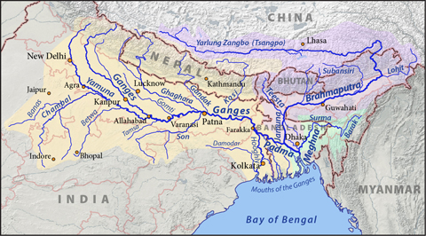
“Under the newly introduced system, we are providing flood forecasting that contains river flow data of 38 measuring stations of 18 rivers including the major river systems such as the Brahmaputra, Ganga/Padma, Surma and Meghna across the country from this monsoon,” Amirul Islam, director of Flood Forecasting and Warning Centre (FFWC), Bangladesh, told thethirdpole.net.
“Earlier, we tried to improve the existing five-day flood forecasting systems to 10 days, but did not manage due to lack of adequate data from Brahmaputra upstream. But this year, with monsoonal river flow data of three points in the Brahmaputra measured in China, we are forecasting for 10 days, though it is experimental,” he added.
It is monsoon In Bangladesh from June to September, the time of maximum flood risk.
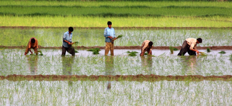
The 10-day warning system will help disaster preparedness and to some extent inform farmers when to prepare their seed beds for paddy.
Under a memorandum of understanding signed in March this year, Bangladesh is receiving Brahmaputra flow data from three measuring points in China from this June. This is in addition to the data from measuring points in India, which Bangladesh has been getting for a number of years now.
See China to give Brahmaputra flow data to Bangladesh, first reported on thethirdpole.net
The Brahmaputra flows from Tibet in China (where it is called the Yarlung Zangbo) to India and then to Bangladesh (where it called the Jamuna) before joining the Ganga.
Till last monsoon, from its own data and from the data supplied by India, FFWC could make forecasts five days in advance. Apart from doubling the warning period, FFWC is now able to make a more accurate five-day forecast.
Asked why the new forecast was “experimental”, Islam said, “We termed the 10-day forecast experimental because we are still in a learning process and we need more data from the Ganga upstream in India.”
India shares water flow information from eight measuring stations on the Brahmaputra, Teesta, Ganga and Barak rivers during the monsoon – four on Brahmaputra, two on Ganga, and one each on Teesta and Barak. All the measuring stations are less than 200 kilometres from the Bangladesh-India border.
More data from India expected
The countries have recently started to talk about sharing water flow from measuring stations further upstream – from Allahabad onwards in the Ganga, and from Dibrugarh in the Brahmaputra. “If we can get the desired water flow data from India on these two rivers, we can make the 10-day forecast in a better manner,” Islam said.
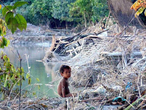
Bangladesh is the furthest downstream country in the world’s largest delta – the Ganga-Brahmaputra-Meghna delta. Floods are almost an annual feature. But they get worse in some years, such as the flood on the Brahmaputra in 2014. The Department of Agriculture Extension (DAE) estimated that around 200,000 hectares planted with paddy and 50,000 hectares with vegetables were inundated last year.
This monsoon, heavy rainfall in the second week of June in Bangladesh and upstream areas of Assam and Meghalaya has already caused a flood. According to the Bangladesh Meteorological Department, this June 13 it rained 663 mm in Bangladesh, compared to the long-term average of 480 mm on this day of the year.
On June 17, FFWC forecast that the water level in the swollen rivers Brahmaputra and Surma-Kushiyara would go down. In flood-affected northern Bangladesh, the only river flowing above the danger level on June 17 was Atrai at Baghabari area of Sirajganj district. It was flowing eight centimetres above the red mark.
But in north-eastern Bangladesh, two big rivers were still in flood. The Surma was 20 cm above the danger level in Sunamganj district, while the Kansha was 53 cm above the danger level river at Jariajanjail area of Netrokona district.
The flow trend showed that semi-flooded areas were now out of risk of further damage, said Arifuzzaman Bhuiyan, sub-divisional engineer at FFWC.
But through central Bangladesh, the Ganga (its main branch in Bangladesh is called Padma) was also rising.
A flood is not necessarily an unmixed disaster in Bangladesh. This is also the season to sow the year’s main rice crop – a variety called Aaman which needs a lot of water in its early stages. Traditionally, floods have also brought a lot of silt that replenished soil fertility, though that supply has dwindled due to construction of dams upstream.