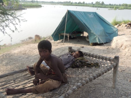
Pakistan is one of the countries in the world most affected by floods droughts and other disasters induced by climate change, according to German Watch’s Climate Risk Index. And within the country, the riverine communities of Doaba are the most vulnerable to flooding disasters. They faced floods in 2010, 2013 and 2014 which caused substantial damage and loss of lives.
The ‘mega’ floods of 2010 affected an estimated 20 million people across Pakistan and 1.9 million homes according to the UN Office for the Coordination of Humanitarian Affairs. Similarly floods in 2011 and 2012 damaged vast areas of Sindh and Baluchistan province affecting an estimated 5.4 million and 4.8 million respectively. In 2013, flooding affected 1.5 million people across eastern Baluchistan, northern Sindh, Punjab and other areas.
Communities desperately need early information about approaching floods to help them avert major losses.
Pakistan has developed a national disaster risk reduction policy along with a comprehensive framework. However there are multiple challenges in its effective implementation. Currently the government has adopted a reactive instead of a pro-active approach towards planning for disaster. For example, the Punjab government mobilised resources for relief and rehabilitation during floods in 2014, yet it has failed to adequately invest in disaster risk reduction.
Efforts are required at a government and community level to develop participatory disaster risk planning and effective early warning systems to address these challenges. In Punjab, local NGO the Doaba foundation developed a GIS based early warning system for Layyah district during the 2013 floods, with the support of Oxfam.
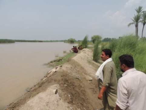
The risk of flooding is forecast using GIS flood modelling and mapping techniques by technical team taking into account the local community’s knowledge about water levels in previous floods, direction of water flow and its pressure on embankments. Water discharge data is collected from the Chashma barrage upstream on the Indus River. The system then calculates the risk of water submerging agricultural land in low lying areas downstream. The calculator is connected to an automatic message system, which sends instant text messages (SMS) to community activists in each of the 500 – 700 villages falling in the path of the flood.
This generally gives communities about 36 – 48 hours to take action before flood water hits the area. Community activists are trained to call an emergency gathering to prepare for the disaster.
 During the 2013 floods along the Chenab River, Amanullah, a committee member of Basti [village] in layyah district, received the early warning message that 629,000 cusecs (cubic feet per second) of water was expected to reach his village. He immediately disseminated this information around the village through the mosque announcements urging people to “move all assets, livestock and children to the safer places or relief camps”. People immediately evacuated the village and saved themselves and their belongings.
 The same year, another community activist, Muhammad Shoaib, received a SMS to say that three lakh cusec of water would be released from Chashma barrage and take 36-40 hours to reach Layyah. He gathered the community and said building a small embankment would help the village survive the flood water. The community agreed and built a small embankment from the place where flood water was expected to enter into the six hamlets of union council Lohanch Nashaib and Jhakha. This saved over 250 acres of agricultural land and almost 2,000 people and other valuable assets.
The strength of this community based system lies in access to reliable information and sharing information with communities in a timely way. The communities are trained in how to respond to disasters and what certain levels of water discharge will mean for their agricultural land. Community members, district governments and local NGOs also shared these early flood warnings with other communities.
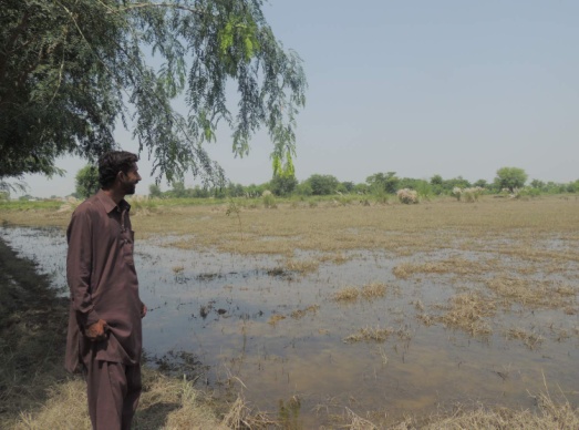
Muhammad Ashraf from village Rakhwan of district Layyah belongs to Sindh Waseeb Forum, on the edge of the river Indus. ‘We cultivated about 70-80 acres of ‘Moung’ [lentil] crop this year, we knew that if water discharge from Chashma barrage exceeds 450,000 cusecs it will flood our fields,” he said. “Usually floods come when our crop is about to be harvested. This July, after receiving the information about water level, we harvested much of the crop before water reached and escaped the big loss.”
A system in which information flows faster than flood water has helped district government, NGOs and other agencies to plan better and reduce the losses during the 2014 floods. The government of Punjab has started to develop similar systems for the whole province. Initially the government model only consisted of information about water levels, however working with Oxfam and other partners, the government has incorporated predictions of the potential impact on people and crops.