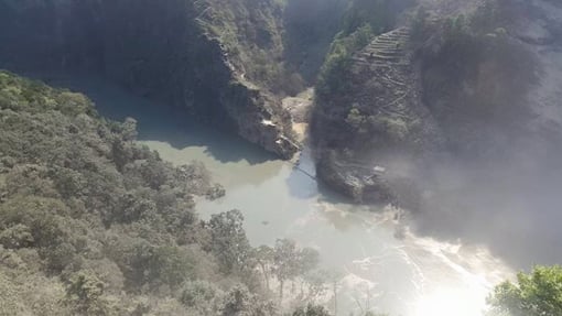

A major landslide in western Nepal’s Myagdi district blocked the Kali Gandaki river late on the night of May 23. According to Nepal government officials, no casualty has been reported, but at least 125 people from one of the affected villages have been shifted to a safer place and thousands downstream have been put on alert. Downstream India may also be affected if the landslide is swept away by the weight of the water now accumulating behind it.
“We have issued an alert to people in seven districts downstream as a large volume of water has been accumulated, forming a lake more than two kilometres in length,” said Dinesh Kumar Thapaliya, Western Regional Administrator, Government of Nepal.
According to Thapaliya, many cities and villages downstream are at risk and people have fled to higher altitude to escape a potential flash flood.
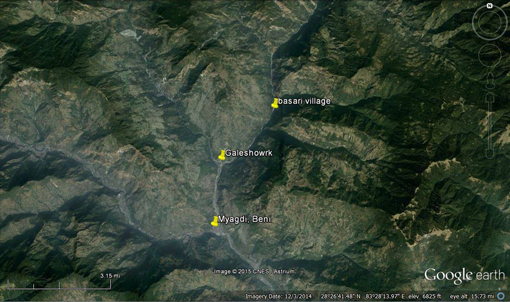
The landslide occurred at Kafaldanda area of Ramche village in Myagdi district.
The Kali Gandaki joins the Narayani river in southern Nepal and the two together form a part of the Nepal-India border. After that, the river – now called Gandak – flows largely through Bihar before joining the Ganga at Patna.
According to a preliminary estimate, at least four million cusec of water has already accumulated behind the landslide spot. “We have been informed by our security forces that the river has been completely blocked and a huge lake has been formed so the team has been observing the situation and providing information accordingly,” added Thapaliya.
According to a Twitter message by the police in Nepal, the districts placed under alert are Myagdi, Baglung, Parbat, Gulmi, Palpa, Syangja, Tanahu and Nawalparasi. Another tweet by the police says, the lake formed due to the landslide has reached a depth of 150 metres within 12 hours of the landslide, and was already more than a kilometre in length. Local residents said that by mid-morning on May 24, the lake was already three kilometres long.
According to local journalists, a Nepal Army helicopter landed near the landslide spot on May 24 morning, but could not reach the exact location, as rocks were still falling down the slopes in the aftermath of the landslide. Myagdi’s district headquarter Beni – which lies along the river – has been evacuated. Local radio stations have been alerting residents downstream.

The landslide occurred despite the absence of any rain in the area. Experts in Kathmandu said it may have been triggered by the major earthquake that shook Nepal and adjoining countries on April 25, plus the aftershocks.
“We can’t say at this moment about whether it was earthquake induced or not but as it is a dry landslide there is high possibility that the reason was earthquake,” said Basanta Raj Adhikari, a landslide expert at Kathmandu-based Tribhuvan University’s Institute of Engineering. “We are heading towards the location to find out more details,” he added.
According to officials at Nepal Electricity Authority (NEA), the 144 megawatt Kali Gandaki Hydro project downstream – one of the few large hydroelectricity projects in the country – has halted its operations after being asked by NEA to do so. It will have a major impact on an already-energy-starved country.
Over 3,000 small and large landslides were spotted by satellites after the earthquake a month ago and experts said tracking these landslides should be a priority.
See Monsoon rains increase risks of landslides in Nepal
“We saw many large landslides in affected areas during our field study a couple of weeks ago and there is a worrying situation. We need to think about it more seriously as the monsoon is approaching,” said Megh Raj Dhital, professor at Tribhuvan University’s Department of Geology.
The monsoon season in Nepal usually starts in the third week of June and goes on till September. The country receives 80% of its annual rainfall during this period. Heavy rainfall often triggers landslides, a peril whose chances have increased as many of the hill slopes in the Himalayan country may have been destabilised by the April 25 quake, which was measured at 7.9 on the Richter scale.