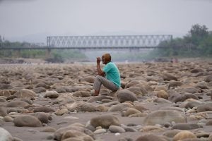
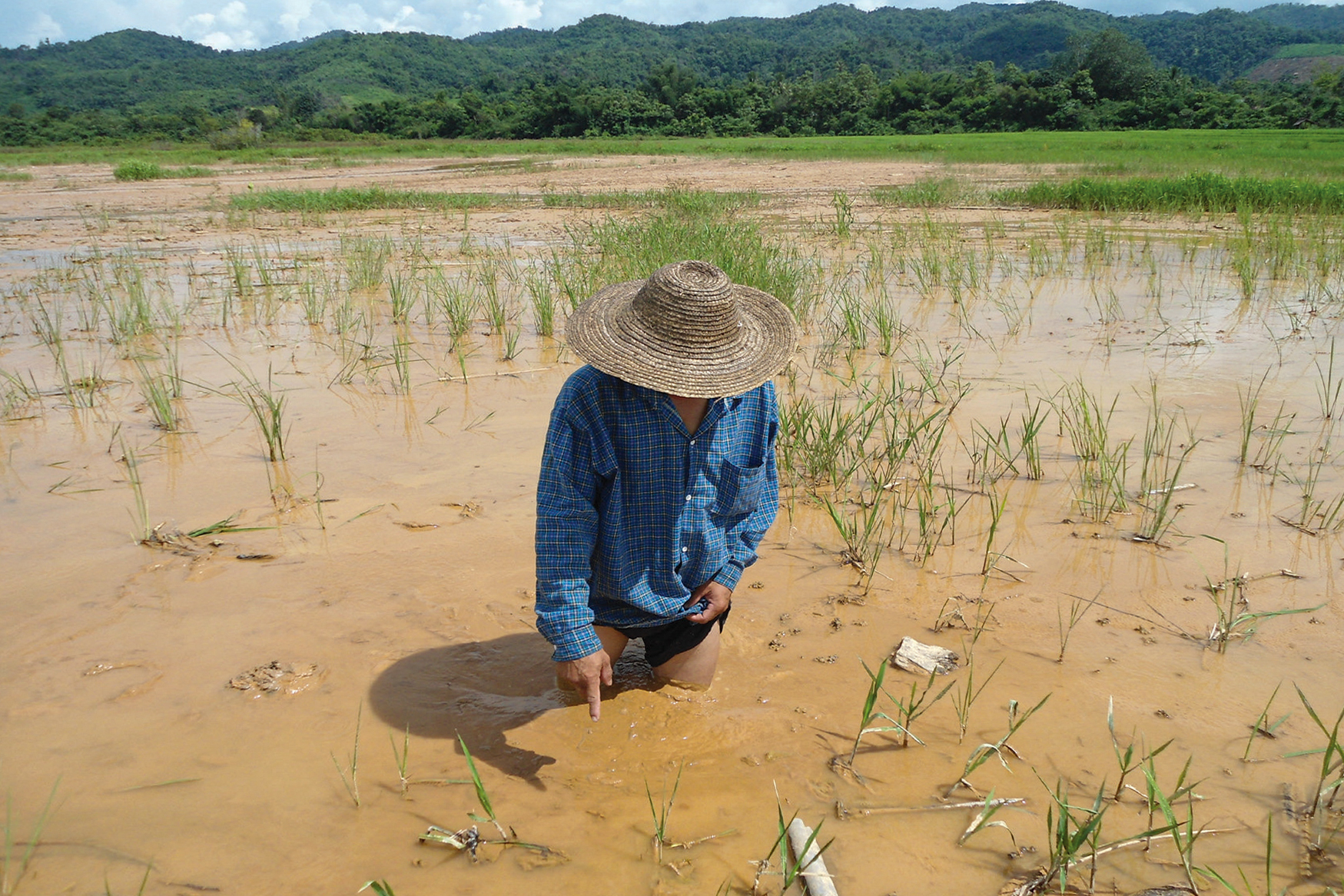
In Mong Len, a rural area in Myanmar’s eastern Shan state, 35-year-old farmer Sai U stood helplessly as his cattle fell – poisoned by the water that had long sustained his family, fields and livestock.
“They drank the water, took a few steps, and just collapsed,” he recalled.
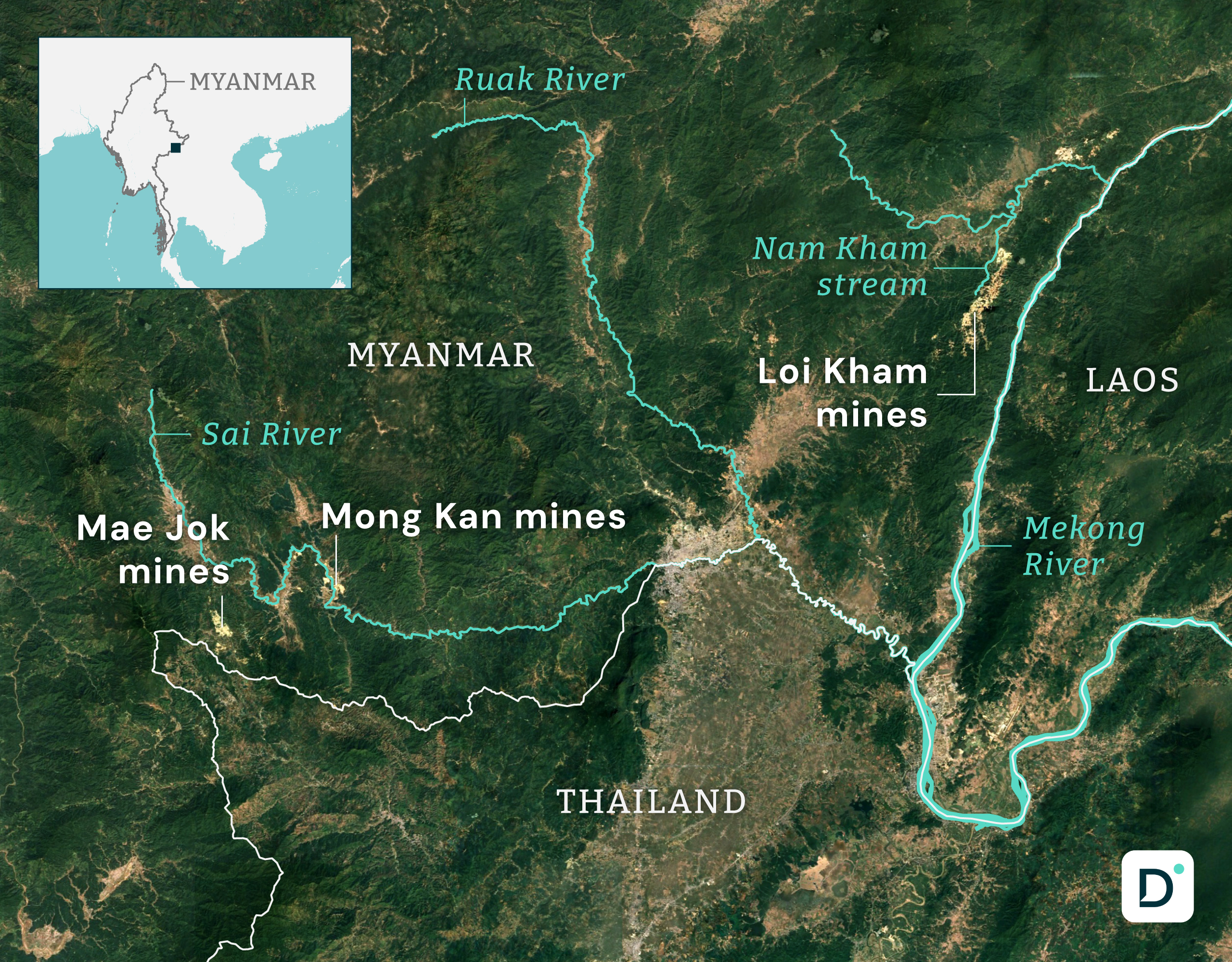
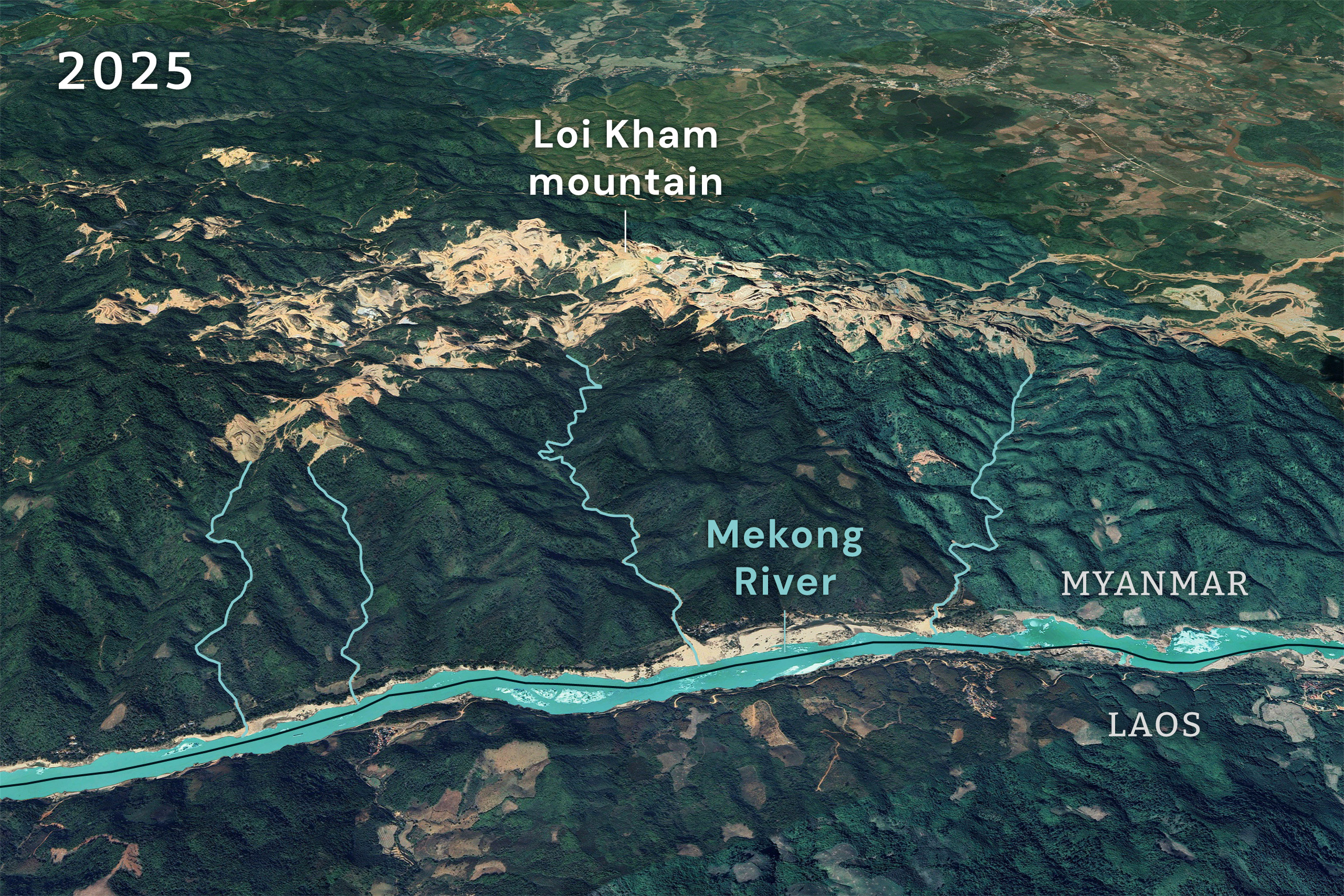
The pond was fed by Nam Kham, or “Golden River,” a stream that flows down from Loi Kham – “Golden Mountain”. The name is inspired by gold flecks said to shimmer in the soil. To villagers, Loi Kham is sacred.
“We never searched for gold,” Sai U said. “The mountain is spiritual – our ancestors live there.”
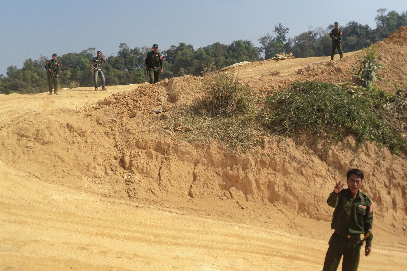
That reverence is not shared by outsiders. Loi Kham has attracted growing interest from mining companies, including from four Chinese operators. The sacred mountain has turned into a hub of unregulated and intensive extraction.
“They first arrived without modern technology, so they simply blasted the whole mountain” Sai U said. They carved into the mountain’s slopes, removing its crest, leaving behind a lunar landscape. Only recently were mineral vein detectors used for targeted drilling, he added.
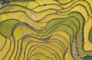
Today, satellite images indicate more than 20 mining sites across eastern Shan state, spanning a combined area of roughly 1,780 hectares, according to our calculations. With little oversight, evidence suggests mining runoff routinely floods fields and homes during heavy rains, turning the Nam Kham dark and foul-smelling.
Satellite imagery and witness accounts acquired by Mekong Eye and Dialogue Earth show a lack of containment infrastructure. The findings raise alarm over how unregulated mining in Myanmar’s uplands may be contaminating water sources that extend far beyond its borders.
Cyanide and mining
Since Myanmar’s 2021 coup, unregulated gold mining has surged across the country, from Indawgyi Lake, a Unesco Biosphere Reserve in the north, to the Tanintharyi Nature Reserve in the south, often encroaching on land abandoned by conflict-displaced communities.
Cyanide compounds are widely used in gold mining to extract the metal from ore, a process known as gold cyanidation. Miners spray a cyanide solution over ore heaps, dissolving the gold and leaving other minerals behind. Despite safer alternatives like thiosulphate, cyanide remains popular for its relatively low cost – especially in unregulated and illegal operations. The gold-rich solution is collected in leaching ponds, often visible as rectangular marks in satellite images. Waste cyanide should be contained in lined tailings ponds – large, deep basins that typically cover a third of a mining site – to prevent environmental contamination.
Satellite photos obtained by Mekong Eye and Dialogue Earth show that gold mines in Loi Kham and across eastern Shan state lack basic tailings infrastructure. The images do not directly show contaminated water flowing into nearby streams. But the absence of any visible treatment facilities strongly suggests wastewater may be reaching waterways that feed Mekong tributaries, raising alarm over potential transboundary contamination.
The images were reviewed by two Thai mining and engineering experts on condition of anonymity. They noted that the layout – particularly the altered landscape and the alignment of suspected leaching ponds – is consistent with gold-processing activities. This was confirmed by accounts from villagers, who acknowledged the presence of the gold mine and the lack of proper tailings ponds.
Although they could not determine the exact extraction method, they stressed that gold cyanidation then collecting the gold from the solution must be carried out on site due to the dangers of transporting cyanide. “It’s too hazardous,” one expert explained. “A spill wouldn’t just release toxic chemicals – it could destroy the entire business.”
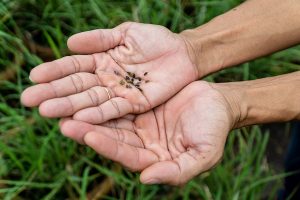
One study found only trace amounts of gold – ranging from 0.12 to 1.89 parts per million (ppm) – in soil samples from Mong Len near the Loi Kham mining area. This level of concentration suggests vast amounts of rock must be processed to extract small quantities of gold, leaving behind large volumes of waste ore laced with cyanide.
Even at low concentrations, cyanide can interfere with cellular respiration, leading to rapid and potentially fatal effects.
While cyanide can break down in certain environments, it can remain hazardous for weeks to months without treatment, posing long-term risks to both ecosystems and human health.
“The lack of safeguards at these mines is worrying, and there’s no one for us to turn to,” said a spokesperson for the Shan Human Rights Foundation (SHRF), a civil society group that has tracked the effects of gold mining in eastern Shan for nearly a decade.
Much of eastern Shan is governed by the United Wa State Army (UWSA), a powerful militia allied with Myanmar’s military junta. However, Mong Len and Loi Kham lie in an area controlled by the Lahu militia. These areas are closed to outsiders. Despite the difficulty of verifying contamination through laboratory testing, local accounts and satellite data paint a troubling picture.
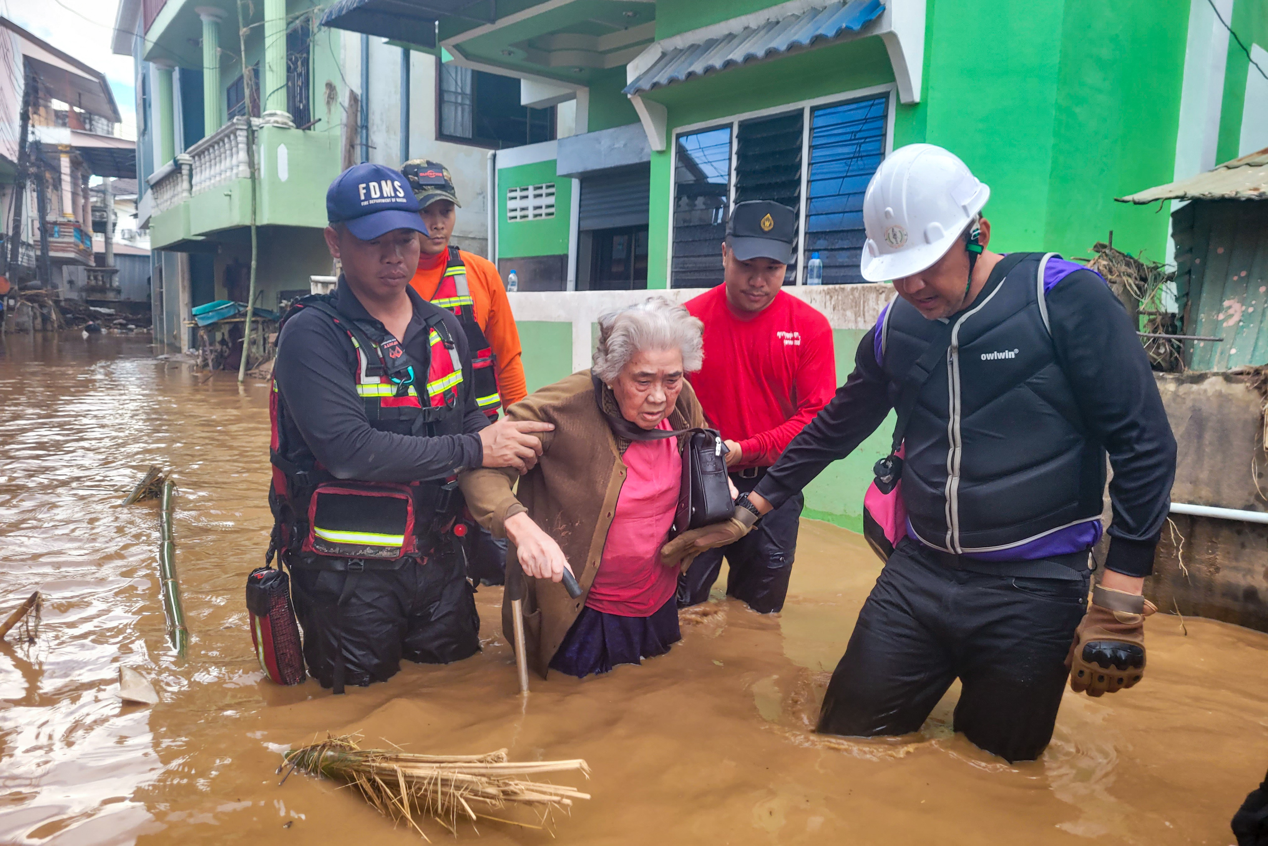
“You can see runoff channels that connect directly to streams feeding into the Mekong,” said one of the experts consulted. A November 2024 report by SHRF confirmed significant mining activity across Shan state. It said that forest loss and soil disruption from mining had worsened erosion, contributing to heavier sediment loads and flooding. These findings built upon an earlier Thai government study that linked severe flooding in Mae Sai district to upstream land degradation, including from mining.
International rivers at risk
Toxic runoff doesn’t stop at the border. Gold-mining operations in eastern Shan sit along two international rivers: the Sai and the Mekong. The Sai, shared by Myanmar and Thailand, is especially affected. Downstream, the Mekong, which sustains about 80% of the nearly 65 million people who live in the Lower Mekong Basin (Thailand, Laos, Cambodia, Vietnam and Myanmar), faces growing contamination risks.
In Mong Len alone, satellite imagery shows at least 10 gold mines sitting above Mekong tributaries. Further southwest, the largest concentration of mines is found in Mong Kan village in Mong Ton township, where operations stretch along both banks of the Sai River for more than five kilometres. One suspected leaching pond sits just 10 metres from the water’s edge.
In September 2024, a historic flood surged into Thailand’s Mae Sai district. Thailand’s Geo-Informatics and Space Technology Development Agency reviewed satellite images after the flood and identified mining in eastern Shan state as an exacerbating factor, along with land use changes from deforestation and intensive agriculture.
“Officials on the Myanmar side claim they can’t intervene because these areas are beyond their control,” said Chaiyon Srisamut, mayor of Mae Sai municipality, referring to the presence of ethnic armed groups. However, many of these groups operate with the military’s tacit approval, raising questions about the will – rather than the ability – to act.
The mayor cited water tests by local authorities, which later revealed traces of mining-related chemicals, including cyanide – though concentrations remained below official safety thresholds.
“I almost wish the [cyanide] levels had exceeded the limit,” he said. “Maybe then someone would be forced to take real action.”

Weak enforcement, rising danger
While the global mining industry has followed the voluntary International Cyanide Management Code since 2000, Myanmar’s mines remain largely unregulated, with environmental oversight having “collapsed” according to reports – even before the 2021 coup.
Thanapon Piman, senior research fellow at the Stockholm Environment Institute, warned against waiting for chemical concentrations to reach crisis levels before taking action.
“When floods occur, river levels rise across the system – including areas near mines where leaching ponds sit along the banks,” he explained. “You can imagine what toxic substances those floodwaters might carry downstream.”
In January, Busadee Santipitaks became CEO of the Mekong River Commission (MRC) Secretariat, an intergovernmental body tasked with managing the Mekong’s transboundary water resources. Santipitaks pledged to strengthen river monitoring in response to increasingly complex water dynamics. But when questioned over cyanide contamination from gold mining in the Mekong Basin, an MRC spokesperson replied: “We have no comment on the specific details of your findings.”
The SHRF said it was not surprised by the response. “We’ve raised this at workshops attended by MRC,” said a spokesperson, who requested anonymity due to security concerns. “They had no response then, and they have no response now.”
Multiple requests to interview Nyi Rang, a spokesperson for the UWSA, about whether the code is implemented in territories under its control went unanswered.
Fear and silence
Fear silences many of those living near the mines.
In Mong Len, protests against the mines were once common. That changed in 2015, when a protester was fatally shot. Open resistance has disappeared since then.
In Mong Kan, 55-year-old Sai Som, and many others like him, were forcibly displaced in 2001 when the UWSA arrived and took control of the area.
“When we were forced to leave, our village headman tried to negotiate. He was detained, tortured and killed,” he said. Now living in displacement camps along the Thai border, families like his are cut off from the land they once farmed.
China’s role in Myanmar’s gold rush
In February 2024, the Extractive Industries Transparency Initiative (EITI), a global coalition of 140 governments, companies and civil society organisations delisted Myanmar, citing the country’s failure to uphold basic governance practices, such as multi-stakeholder oversight and data transparency.
In the vacuum left by weak regulations and the ongoing conflict, Chinese miners have carved out a dominant presence in Myanmar’s gold-rich war zones, particularly along the porous border with China.
China, the world’s largest gold producer in 2023, with nearly 380 metric tonnes, sees overseas gold mining as a strategic investment to secure its domestic supply and to leverage geopolitical influence through its Belt and Road Initiative (BRI). In 2024 metals and mining investments under BRI reached a record USD 21.4 billion, according to the Griffith Asia Institute. Myanmar, like other countries with fragile governance, has become part of this larger trend. While Chinese companies face tight regulation at home, their overseas operations have drawn legal scrutiny, including in Indonesia and the Democratic Republic of Congo.
In contrast, no legal action has been taken against Chinese mining operations in Myanmar since the 2021 coup. The UWSA controls large stretches of gold-rich territory. Any disruption to mining operations under UWSA control risks drawing China further into Myanmar’s civil conflict – an outcome neither the Myanmar military not the country’s patchwork of revels groups if eager to provoke.
With few avenues for redress and dissent silenced within Myanmar, villagers like Sai U can only watch on as their sacred mountains and rivers are desecrated. Meanwhile, downstream, millions remain largely unaware of the slow-moving crisis flowing toward them.
Editor’s notes:
This story was supported by Earth Journalism Network through Mekong Eye and Dialogue Earth. Versions may vary between outlets.
All mine measurements were based on satellite imagery. Names and some locations in Shan state have been changed to protect the safety of individuals.